The Richat Structure – The Eye of the Sahara as Atlantis
Location
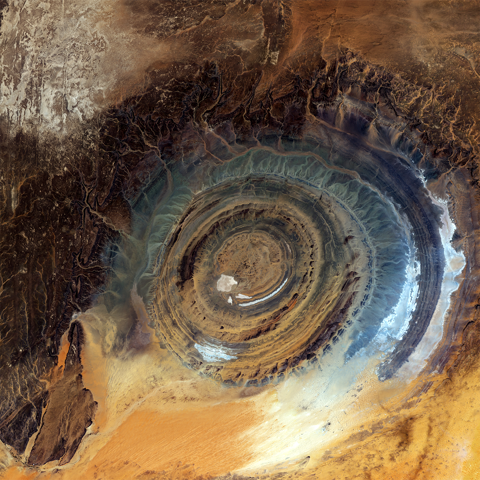
Nestled in the heart of Mauritania, West Africa, the Richat Structure sprawls across the Adrar Plateau in the vast Sahara Desert. Positioned at approximately 21.13°N, 11.4°W, this geological wonder lies far from any modern coastline, surrounded by an arid expanse that stretches for thousands of miles. Known as the "Eye of the Sahara" for its striking circular pattern—visible even from space—the Richat Structure measures 40 kilometers (25 miles) in diameter, a scale that has drawn the attention of those seeking the lost civilization of Atlantis.
Historical Context
The story of Atlantis begins with Plato, the ancient Greek philosopher who, around 360 BCE, penned the dialogues Timaeus and Critias. He described Atlantis as a grand island empire, its capital adorned with concentric rings of water and land, flourishing with wealth and power until it vanished beneath the waves in a single day and night around 9,600 BCE—9,000 years before his time. For centuries, scholars and explorers have scoured the Mediterranean and Atlantic for this sunken realm, assuming its watery grave lay near coasts or islands. Yet, in the 21st century, an unexpected contender emerged from the desert sands: the Richat Structure.
This hypothesis gained prominence through modern media, notably when Jimmy Corsetti of the YouTube channel Bright Insight spotlighted it in 2018. His video, amassing millions of views, argued that the Richat’s circular layout and the Sahara’s ancient climate align with Plato’s tale, shifting focus from traditional oceanic sites to an inland African anomaly. While geologists have long studied the structure as a natural formation—an eroded dome shaped over millions of years—its eerie resemblance to Atlantis’ described topography has ignited a wave of speculation, fueled by online communities on platforms like X and beyond.
The idea isn’t entirely new. Earlier theorists, like 19th-century occultists, occasionally pointed to Africa as a cradle of lost civilizations, but the Richat’s specific connection to Atlantis crystallized in the digital age. Its rise reflects a blend of ancient myth and modern curiosity, challenging the assumption that Atlantis must lie submerged in the sea.
Evidence Supporting the Richat Structure as Atlantis
Geological and Visual Parallels
The Richat Structure’s most striking feature is its concentric rings, a series of ridges sculpted by the erosion of alternating sedimentary and volcanic rock layers. From above, these rings—extending up to 23 kilometers from the center—form a near-perfect bullseye, echoing Plato’s vision of Atlantis as a city encircled by three water channels and two land bands. The innermost ridge, about 500 meters wide, could correspond to the "metropolis" he detailed, a central hub roughly 5 stadia (1 kilometer) across, home to temples and palaces. At the core lies a raised, flat expanse—often dubbed the "bullseye"—which enthusiasts see as the remnants of Plato’s central island, eroded but still distinct.
The scale of the Richat further bolsters its case. Plato claimed Atlantis was "larger than Libya and Asia combined," a reference to ancient regions (modern North Africa and Asia Minor) rather than continents. While the structure’s 40-kilometer diameter doesn’t rival a continent, it dwarfs Mediterranean candidates like Santorini (16 kilometers) or Crete (260 kilometers long but narrow), offering a grandeur closer to Plato’s hyperbolic imagination. This visual and dimensional alignment has become a cornerstone of the hypothesis, captivating those who see the Eye of the Sahara as a fossilized blueprint of Atlantis.
Ancient Climate and a Desert "Sinking"
The Sahara wasn’t always a desert. During the African Humid Period, from roughly 12,000 to 5,000 years ago, this region teemed with life—rivers snaked through savannas, lakes shimmered under the sun, and wetlands supported diverse ecosystems. This timeframe overlaps with Plato’s 9,600 BCE dating, suggesting the Richat could have been a fertile oasis capable of sustaining an advanced society. Some researchers propose that Lake Iferouane, a now-vanished body of water, once lapped at the structure’s edges, potentially feeding canals or moats akin to those Plato described.
The "sinking" of Atlantis poses a puzzle for an inland site, but proponents offer a creative solution: the end of the Humid Period brought rapid desertification between 5,000 and 3,000 BCE, transforming a lush landscape into barren sand. A catastrophic flood—perhaps from shifting monsoons or a tectonic jolt—could have inundated the area before it dried out, leaving the Richat as a stranded relic. Geological traces of ancient riverbeds radiating outward lend credence to this idea, hinting at a watery past abruptly lost to time. This reimagining of "sinking" as a metaphorical burial under desert sands bridges the gap between Plato’s narrative and the Sahara’s history.
Cultural and Historical Threads
Plato places Atlantis "beyond the Pillars of Hercules," traditionally the Strait of Gibraltar. The Richat Structure lies southwest of this point, accessible via ancient trans-Saharan routes that may have linked it to Mediterranean cultures. Some theorists suggest Plato’s "sea" was a mistranslation or symbolic term, encompassing rivers, lakes, or a flooded Sahara rather than an ocean. This interpretation stretches the text but aligns the Richat with his directional clue.
Local Berber traditions offer faint echoes of lost cities and floods, though no explicit Atlantis connection exists. These oral histories, passed down through generations, might preserve a dim memory of a thriving Richat-based civilization, proponents argue. Meanwhile, the structure’s isolation—far from Greece—could explain why its fate became myth, distorted through centuries of retelling until it reached Plato’s ears.
Archaeological Hints and Untapped Potential
The Richat’s remote location has hindered excavation, but the broader Sahara yields clues of human presence. Acheulean tools, dating from 1.5 million to 200,000 years ago, mark prehistoric activity nearby, while Neolithic artifacts (post-10,000 BCE)—pottery, arrowheads, and grinding stones—suggest later settlement across the region. None have been found within the structure itself, but its inaccessibility leaves open the possibility of buried secrets. Unlike submerged sites, the Richat invites surface exploration, a tantalizing prospect for those convinced Atlantis lies in plain sight.
Comprehensive Analysis
Strengths of the Hypothesis
The Richat Structure’s visual match to Plato’s Atlantis is undeniable. Satellite imagery reveals a pattern so precise it seems almost engineered, setting it apart from natural formations elsewhere. Its scale surpasses most rival candidates, offering a grandeur that feels worthy of an empire. The Sahara’s ancient wet phase provides a plausible setting—a verdant hub where a sophisticated society could have flourished—while the shift to desert evokes a lost-world tragedy. Unlike underwater theories requiring costly dives, the Richat’s accessibility beckons researchers, promising answers with each new expedition.
The hypothesis thrives in the digital era. Since Corsetti’s 2018 video, online forums and X posts have dissected its dimensions, climate data, and Plato’s words, building a passionate following. This grassroots momentum contrasts with the slower pace of academic theories, amplifying the Richat’s allure as a people’s Atlantis.
Weaknesses and Challenges
Yet, the theory stumbles on hard evidence. No ruins, canals, or artifacts of an advanced civilization grace the Richat or its surroundings. Geologists classify it as a natural dome, formed 100 million years ago when magma uplifted sedimentary layers, then eroded over eons into its current shape—not a city carved by human hands. The Neolithic Sahara hosted hunter-gatherers and early pastoralists, but their simple tools and settlements fall short of Atlantis’ described splendor.
The inland setting poses another hurdle. Plato’s Atlantis was an oceanic island, its fate tied to a "boundless sea." Even in a wetter era, the Richat was a landlocked feature, possibly near lakes or rivers but not surrounded by an ocean. This clash demands a reinterpretation of Plato’s text—perhaps "sea" meant any water body—which strains credibility for traditionalists.
The geological timeline further complicates matters. The Richat’s formation predates humanity by millions of years, and its erosion unfolded over vast epochs. Any "sinking" event—flood or desertification—must fit within human history, yet no seismic or hydrological catastrophe of sufficient scale aligns with 9,600 BCE. Culturally, Atlantis’ Greek ties—its war with Athens, its Poseidon worship—feel distant from Saharan peoples, with no evidence of trade or migration to bridge the gap.
Science vs. Speculation
Mainstream science offers a clear verdict: the Richat is a geological anticline, its rings a product of natural processes, not human design. Studies like Matton et al. (2005) detail its uplift and erosion, dismissing artificial origins. Archaeologists find no trace of urban development, contrasting the Richat with sites like Santorini, where Minoan ruins tell a tangible story. Enthusiasts counter that Mauritania’s isolation has limited exploration—only a fraction of the structure has been surveyed—leaving room for future revelations. This optimism, while compelling, leans heavily on hope rather than data.